Central Coast Weather — Saturday, November 14, 2026

Good afternoon — hope you’re having a good afternoon. It’s Saturday, November 14th — World Diabetes Day, and National Pickle Day too. A big day around here: tonight’s the 17 Strong Celebration of Victory fundraiser, and the weather is giving us a little bit of everything to talk about on the way there.

Two words for this afternoon: clearing, and surf. The big story today is the huge waves — even though the skies are clearing, the ocean is putting on the biggest show of the week. Here’s the full picture.

Weather Anywhere

Want the forecast for somewhere else? Type any place — the forecast, stripped down to the words that matter.

Forecasts: U.S. places from the National Weather Service; elsewhere from Open-Meteo. Full Weather Anywhere page

Get Dave’s Weather as an app

Add the forecast to your home screen — one tap, and it’s right there every morning.

On iPhone: tap Share, then Add to Home Screen to install Dave’s Weather.

The big picture

A cold front moved across the Central Coast Friday, and it was a good, soaking rain. It is exiting to the south this morning, and the skies are clearing behind it — a few showers may linger into this afternoon, mainly near the Santa Barbara South Coast, but the rain is basically done for now. Highs today run from the mid-60s along the coast to the low 70s inland, with a northwest breeze at 10 to 20 mph, a little gustier along the coast.

We are dry tonight and into Sunday evening, under a ridge of high pressure, with a light offshore flow developing by Sunday. Then a second front approaches Sunday night and moves through Monday — the rain starts late Sunday and continues into Monday night, with showers lingering into Tuesday morning, on and off. It looks light — a quarter-inch or less, with the best totals across northwest San Luis Obispo County. Northwest winds pick up Monday night across the I-5 Corridor and the Santa Ynez Range, with a 30 to 40 percent chance of advisory-level gusts.

Looking ahead, Wednesday and Thursday bring the next system in — the models have been a bit inconsistent on timing and amounts, but it could bring one to two inches of rain, with the first real chance of snow at higher elevations since the current pattern. We’ll refine that as we get closer.

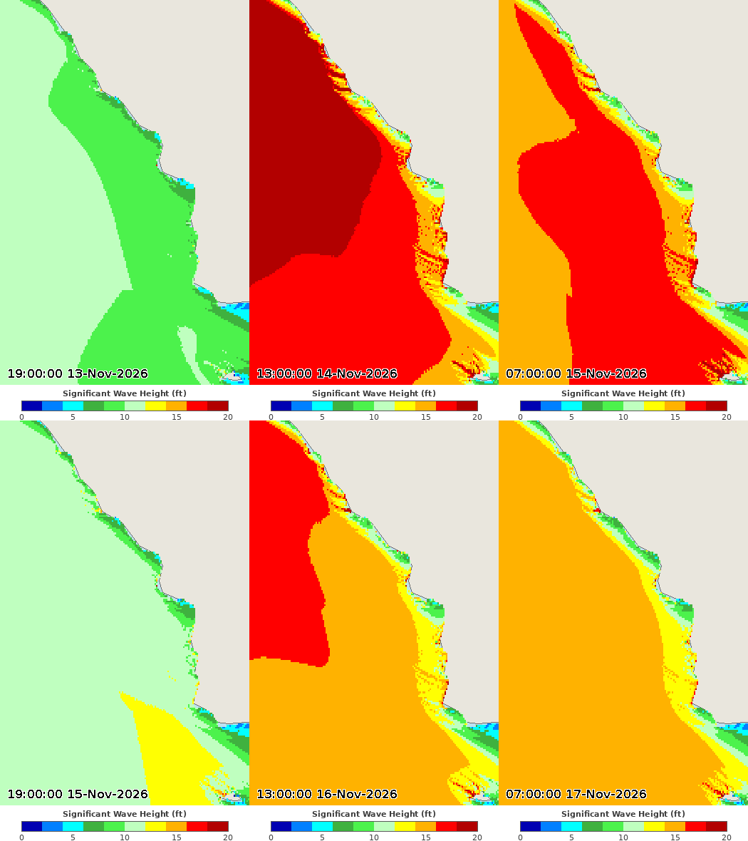
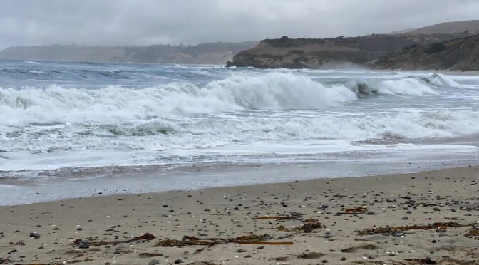
And then there’s the surf. A big, long-period west-northwest swell is building in, and it is the story of the weekend. Breakers will reach 18 to 25 feet on west-facing beaches today, with sets up to 25 to 30 feet — the highest surf of the season so far. A High Surf Warning is up through 3 AM Sunday, and the water is dangerous: strong rip currents and sneaker waves. If you’re headed to the beach today, watch from well back — this is not a day to get close to the water.

It’s a great afternoon to check out the rainfall totals later in this post.

Check this out

This reel making the rounds today shows what this swell is doing to piers and seawalls:

John Lindsey’s morning post digs into the local numbers — the Port San Luis tide gauge, tides running well above predicted, and why the noon high tide mattered:

And the National Weather Service posted the buoy numbers behind the big surf — 32 feet at 21 seconds at buoy 46042:

And this is exactly why you listen to the warnings — a man out on the rocks at Morro Bay today gets swallowed whole by a set. He climbed out, somehow:

More Morro Bay — drone footage of today’s sets exploding over the jetty and clear over the harbor entrance marker:

And up the coast in Cayucos, the surf was pushing right onto Front Street around the high tide:
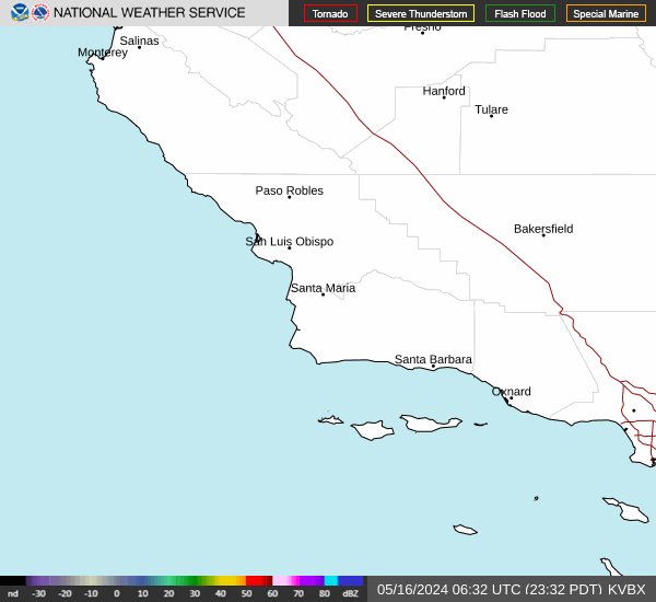
Latest radar — click to animate

Rainfall outlook

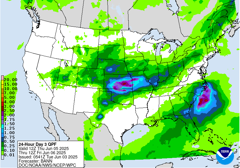
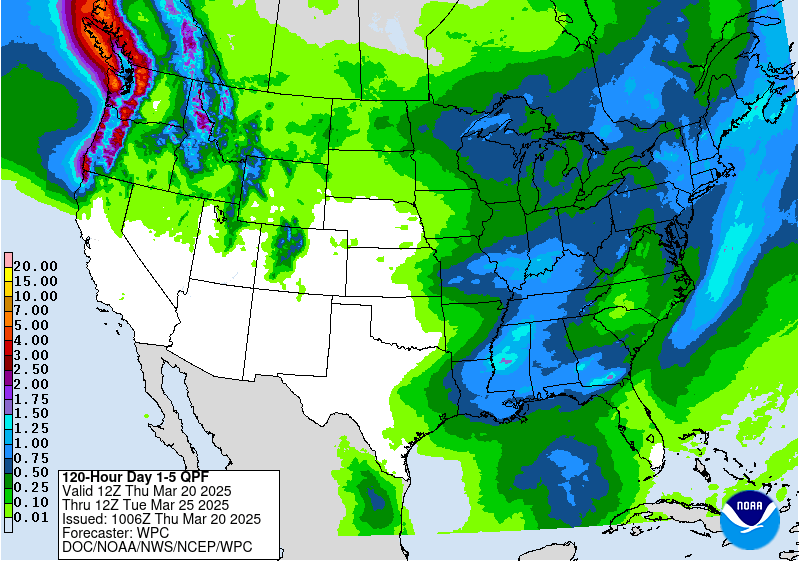
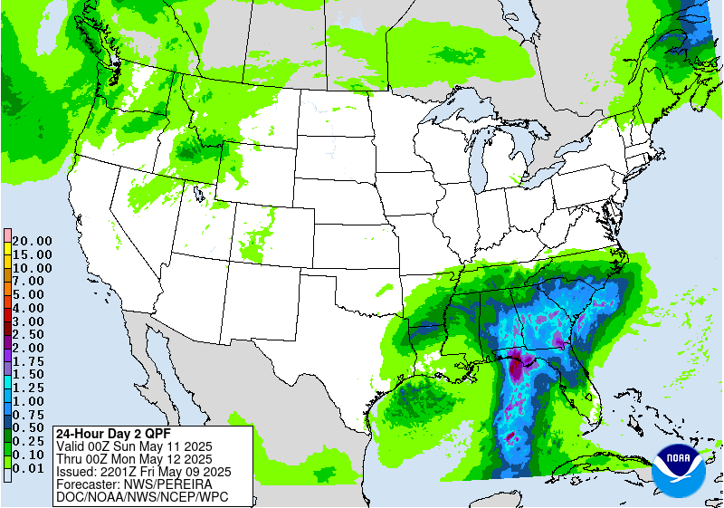
Rain chances pick up again Sunday night and Monday, with the next round of steady rain arriving Monday. Here’s how the rainfall outlook looks over the next few days.
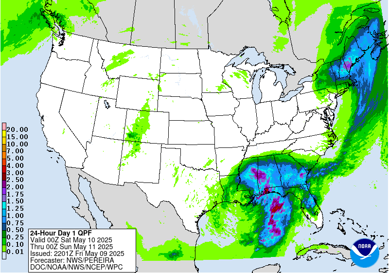
Rainfall outlook — Day 1 (today)
Rainfall outlook — Day 2 (tomorrow)
Rainfall outlook — Day 3 (Monday)
Rainfall outlook — 5-day total

SLO County Rainfall

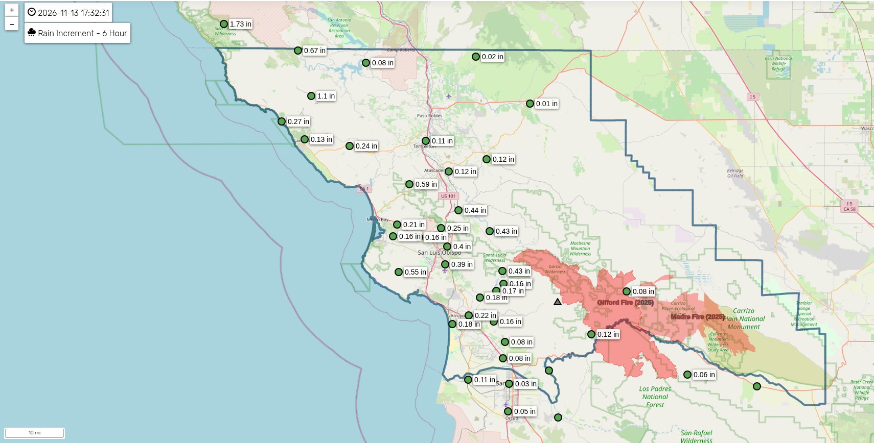
Here’s how much rain actually fell across SLO County in the last day — and the totals are impressive after Friday’s front.
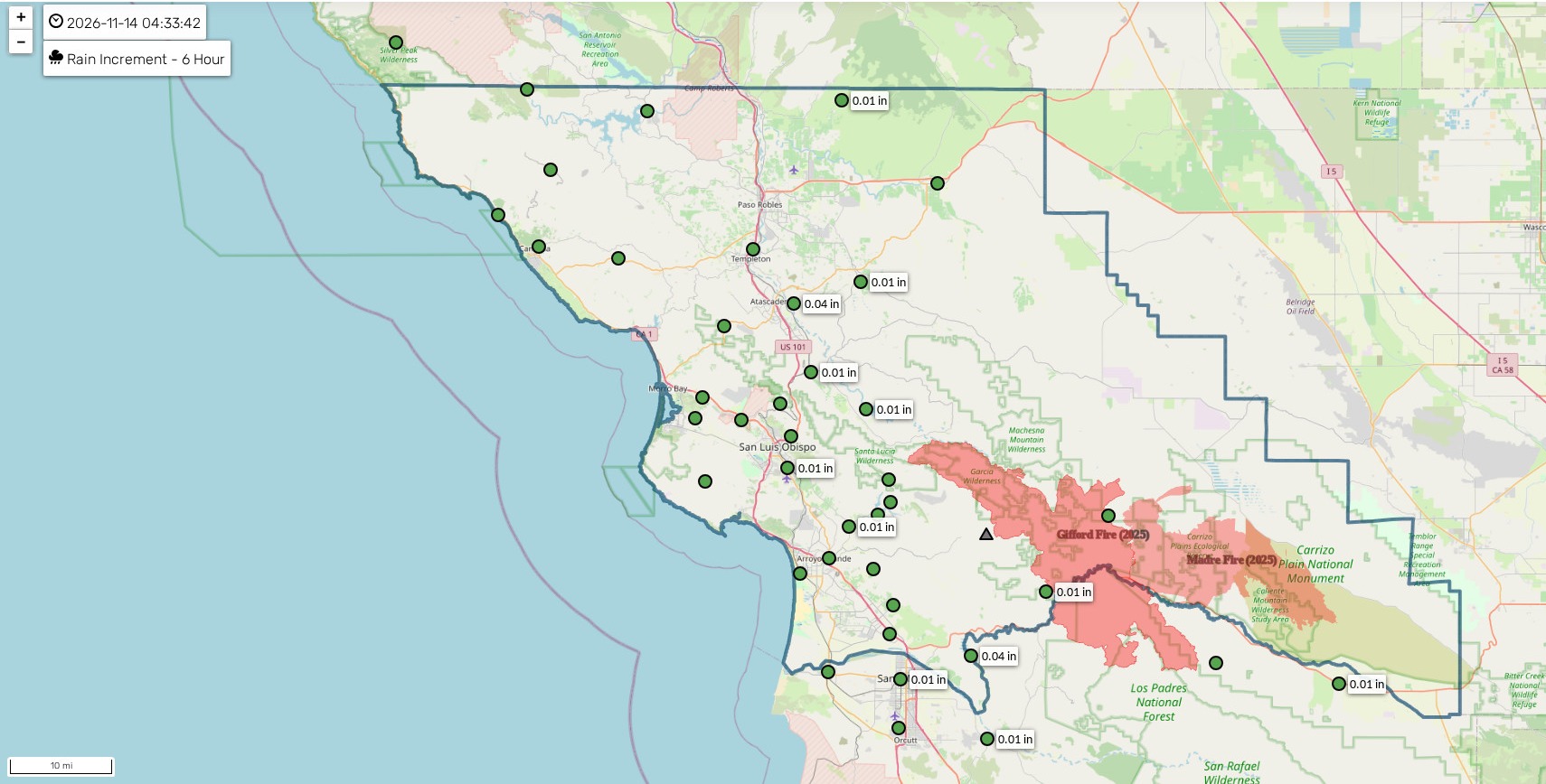
SLO County rainfall map — 6 hour total

Click map to enlarge

Source: Public Works of SLO County. Click here for an interactive map and more

Frontal animation

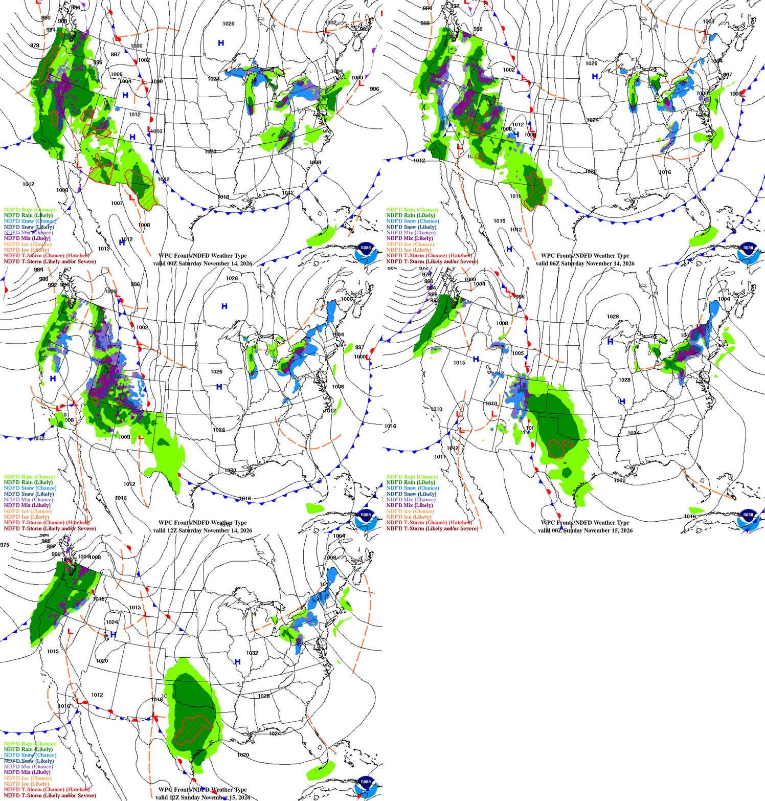
Here’s the front that brought Friday’s rain, as it moves out and the next one lines up behind it.
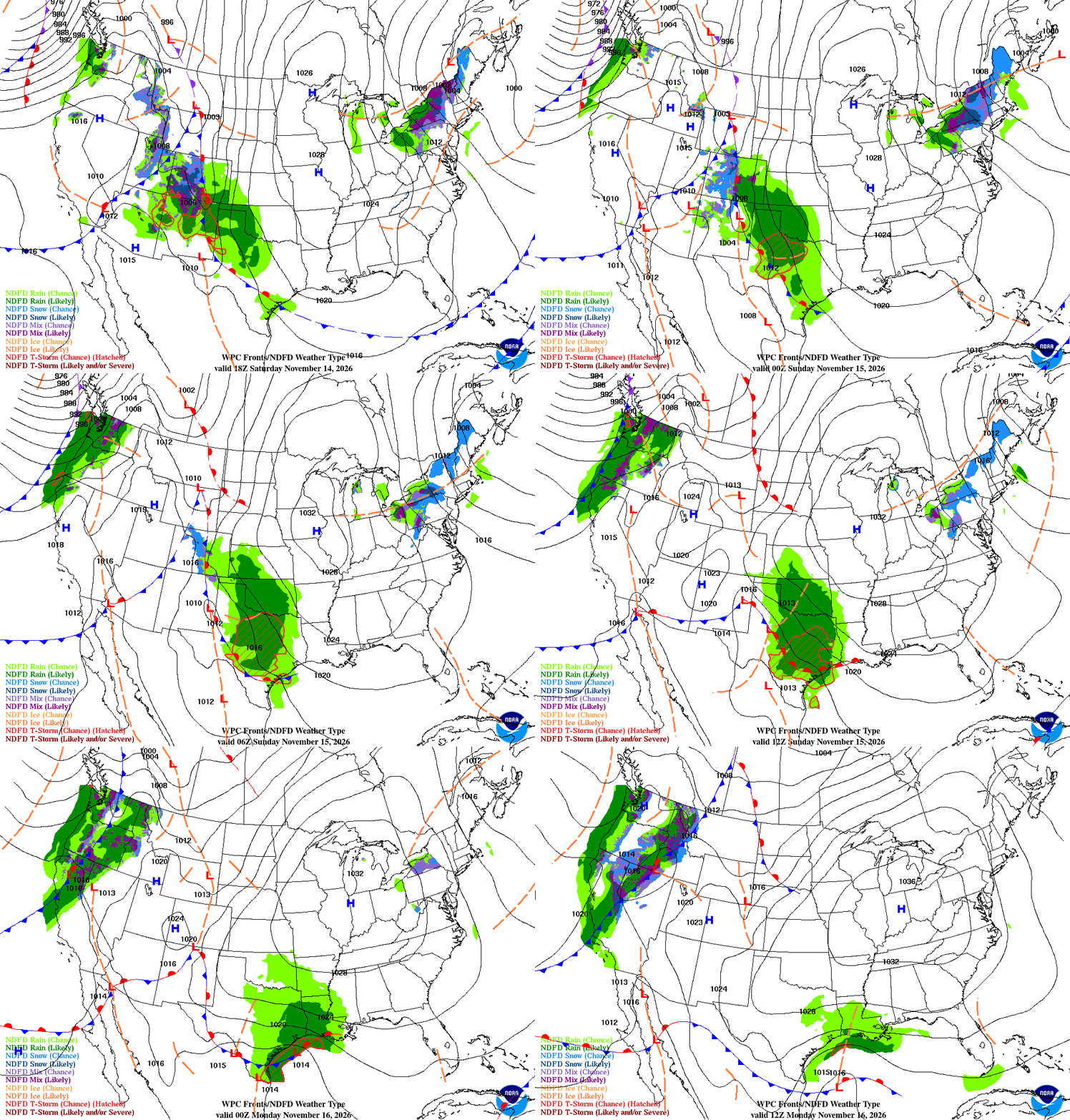
Coastal valleys

  • Showers ending this morning, then partly cloudy this afternoon. Highs in the mid- to upper 60s. Northwest winds 10 to 20 mph, a little gustier along the coast.
  • Tonight, mostly clear and cool, with lows in the mid-40s. Sunday is mostly sunny and a little warmer, with highs in the upper 60s to low 70s.
  • Rain returns late Sunday into Monday, with showers on and off through Tuesday morning. Totals look light — a quarter-inch or less.

Beaches

  • A big, long-period west-northwest swell is building in — breakers 18 to 25 feet on west-facing beaches today, with sets up to 25 to 30 feet. A High Surf Warning is in effect through 3 AM Sunday.
  • Today: highs in the mid-60s, northwest winds 15 to 25 mph, gusty. Dangerous rip currents and sneaker waves — stay well back from the water.
  • Sunday: surf gradually eases, but stays elevated, with breakers still running 10 to 15 feet. Monday: surf continues to drop, with a new swell arriving late in the week.

Interior valleys

  • Showers ending this morning, then a mix of sun and clouds this afternoon. Highs in the upper 60s to low 70s. Northwest winds 10 to 20 mph, gusty in the afternoon.
  • Tonight, clear and cool, with lows in the low 40s. Sunday is mostly sunny and warmer, with highs in the low to mid-70s.
  • Rain returns late Sunday into Monday, on and off through Tuesday morning. Totals look light — a quarter-inch or less, with the best totals across northwest San Luis Obispo County.

Santa Barbara Southcoast

  • A few showers linger into this afternoon, then clearing. Highs in the mid- to upper 60s. Northwest winds 10 to 20 mph.
  • Tonight, mostly clear, with lows in the upper 40s. Sunday is mostly sunny and a little warmer, with highs in the upper 60s to low 70s.
  • Rain returns late Sunday into Monday, with showers on and off through Tuesday morning. Totals look light.

Marine — Central Coast

A big west-northwest swell is building in, with seas 10 to 14 feet today and breakers 18 to 25 feet along west-facing beaches — the highest surf of the season so far. A High Surf Warning is in effect through 3 AM Sunday. Northwest winds 15 to 25 knots, with gusts to 30 knots, easing tonight. Small Craft Advisories are up for the nearshore waters.
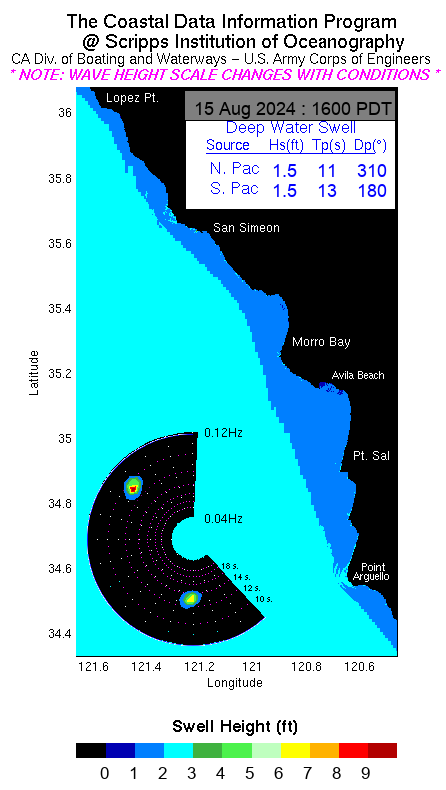
Current swell heights — Point Conception (CDIP)

Marine — Southcoast

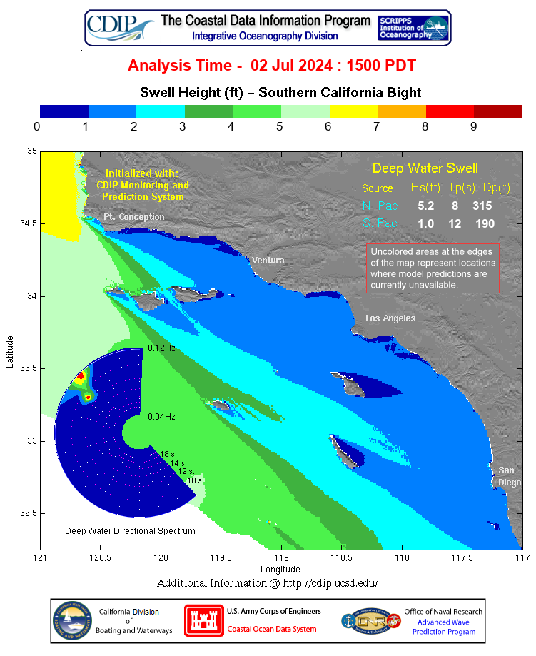
Current swell heights — Southern California Bight (CDIP)

Southwest swell continues to ease, with seas 4 to 6 feet and a mix of west and south swell. Northwest winds 10 to 20 knots, with gusts to 25 knots. A Small Craft Advisory is in effect for the outer waters through this afternoon.
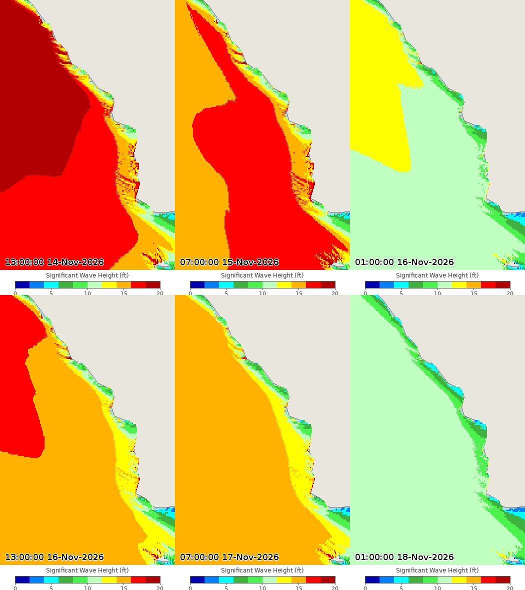
Wave height forecast — click for forecast

Tools

El Niño Status

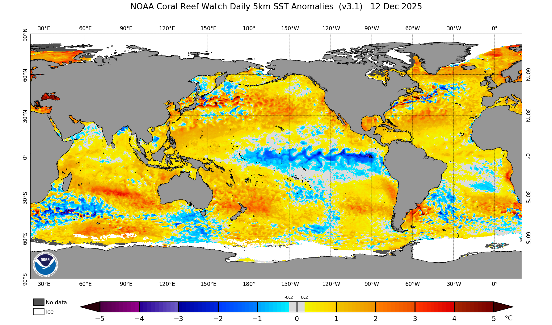
A strong El Niño is in place. Sea-surface temperatures in the Niño-3.4 region are running about 2.5°C above average, with Niño-3 at +3.6°C and Niño-1+2 at +4.4°C. Forecasters expect the strong-to-very-strong event to continue through January to March 2027, with about a 60 percent chance it becomes a historic event. The next CPC update is December 10, 2026.

Long-range outlooks
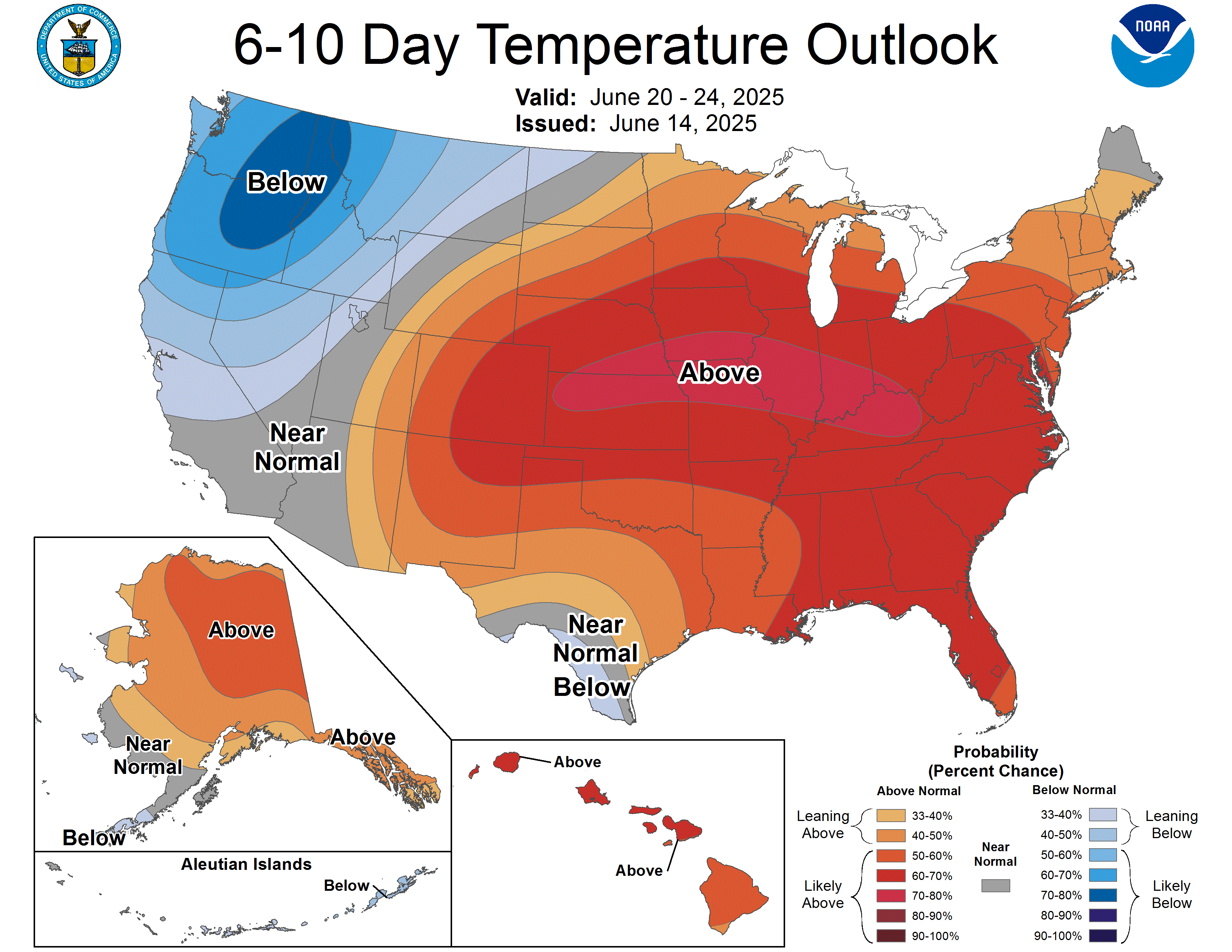
Central Coast Weather — Friday, November 13, 2026

Good morning — hope you’re having a good morning. It’s Friday, November 13th — World Kindness Day, and yes, Friday the 13th too. A good morning to be kind to someone, and to stay dry while you’re at it.

“The best thing one can do when it’s raining is to let it rain.” — Henry Wadsworth Longfellow

Two words for this morning: rain, and waves — big ones. The rain is on and off into next week, and the surf is running 18 to 25 feet on west-facing beaches. Here’s the full picture.

How this page works: the further down you go, the deeper it gets. The big picture first, then your local forecast, the radar, the rain and wave forecasts — and further down, the extended outlooks, El Niño, and the rainfall picture.

GOES-18 GeoColor, CONUS

The big picture

We are in a classic November pattern — a parade of Pacific systems, each bringing a pulse of rain, separated by brief dry breaks. The first impulse, an upper low tracking over the water toward northern Baja, is already producing scattered showers this morning. Rainfall rates have generally stayed under a quarter-inch per hour, though a few spots have seen half an inch per hour. The showers are moving quickly, which limits the flooding risk, and there is still a slight chance of a thunderstorm this morning.

The main event arrives this morning. A more classic cold front pushes into San Luis Obispo County this morning and sweeps southeast across the area through Saturday morning, bringing a 3- to 5-hour period of light to moderate rain. Rain rates should stay around a quarter-inch per hour or less. All told, expect 0.25 to 0.75 inches through Saturday morning, with isolated spots near an inch where a heavier shower or thunderstorm sets up.

After the front clears Saturday afternoon, we get a dry break — Saturday afternoon through Sunday evening looks dry. But do not put the umbrella away: another system arrives Sunday night, and the wet, unsettled pattern continues into next week, with rain likely Monday and again Wednesday into Thursday. The Monday system looks lighter, around a quarter-inch or less, while the midweek system could bring 0.25 to 1.00 inches.

Latest radar — click to animate

Rainfall outlook

Day 1 — 24-hour rainfall total
Day 1 — rainfall for Day 1 only (24-hour total)
Day 2 — 24-hour rainfall total
Day 2 — rainfall for Day 2 only (24-hour total)
Day 3 — 24-hour rainfall total
Day 3 — rainfall for Day 3 only (24-hour total)
5-day total rainfall (Days 1–5)

SLO County Rainfall

SLO County rainfall map — 6 hour total

Click map to enlarge

Source: Public Works of SLO County. Click here for an interactive map and more

Frontal animation

Short-range fronts and weather type
Short-range fronts and weather type, looping Nov 14–15, 2026

Coastal valleys

  • Rain this morning, 0.25 to 0.75 inches through Saturday morning; highs mid-60s to around 70; south winds 15 to 25 mph shifting northwest this morning.
  • Saturday turns sunny after a partly cloudy morning; dry through Sunday evening.
  • Rain returns Monday, then again Wednesday into Thursday; highs upper 50s to mid-60s, lows in the 40s.

Beaches

  • Rain this morning, high near 67; breezy southwest winds gusting to 25; another tenth to a quarter-inch.
  • Saturday is sunny and dry, high near 67 — but surf is the story: 18 to 25 feet, with a High Surf Warning 9 p.m. Friday to 3 a.m. Sunday and a Coastal Flood Warning 3 a.m. to 6 p.m. Saturday. Expect beach erosion, flooding of low-lying walkways and parking lots near high tide, dangerous rip currents, and breaking waves at the Morro Bay Harbor entrance and the Pismo and Cayucos piers.
  • Rain returns Sunday night and Monday, then again Wednesday.

Interior valleys

  • Rain this morning; highs lower to mid-60s, lows mid-40s to around 50.
  • Saturday is sunny, highs mid- to upper 60s; dry through Sunday.
  • Rain Monday and again Wednesday into Thursday; Monday night lows dip into the mid- to upper 30s, Tuesday night into the mid-30s to around 40 — the coldest nights of the stretch.

Santa Barbara Southcoast

  • Rain this morning, high near 73; a tenth to a quarter-inch.
  • Saturday is sunny and warm, high near 74; dry through Sunday.
  • Rain Monday, mainly before 4 p.m., high near 67; a chance of rain lingers Wednesday and Thursday, highs near 67.

Marine — Central Coast

Current swell heights — Point Conception (CDIP)

A Small Craft Advisory runs through late Tuesday night. West-southwest winds around 20 knots gusting to 25 this morning, with rain and a west swell of 8 feet at 14 seconds. Seas build fast: dangerously large seas peak Saturday at 18 to 22 feet in the outer waters and 14 to 20 feet in the inner waters north of Point Sal, with a secondary peak Monday. Dangerous breaking waves are expected at the Morro Bay harbor entrance.

Current swell heights — Southern California Bight (CDIP)

Marine — Southcoast

Southwest winds around 10 knots this morning, showers through the morning, wind waves 1 foot or less. Saturday is sunny with northwest winds 5 to 10 knots. A Small Craft Advisory is likely Saturday across the western Santa Barbara Channel. Monday and Tuesday bring a 60 to 80 percent chance of Small Craft Advisory-level winds and a 30 to 40 percent chance of gale-force winds south of Point Conception.

Wave height forecast — click for forecast

Tools

Live Doppler Radar
Live Doppler Radar — click to open
Live Rainfall Map icon - blue rain cloud and rain gauge
Live Rainfall Map — click to open

El Niño Status

Sea surface temperature anomalies
Sea surface temperature anomalies — latest

El Niño is strengthening, and it is now a big one. Sea surface temperatures in the eastern equatorial Pacific are running more than 4 degrees Celsius above average, with the key Niño-3.4 region at +2.5°C, Niño-3 at +3.6°C, and the far eastern Pacific at a remarkable +4.4°C. The warm water runs deep, too — subsurface temperatures are more than 10 degrees above average at depth — a deep reservoir that will keep feeding this event.

The Climate Prediction Center says a strong-to-very strong El Niño is likely through January–March 2027, at better than a 79 percent chance, and there is now about a 60 percent chance this becomes a historic El Niño, exceeding any since 1950. It is expected to keep strengthening before it begins to weaken in early 2027.

What it means for us: a strong El Niño tilts the odds toward a wetter-than-average winter across California, with more storms tracking into the state. It is not a guarantee — even a very strong El Niño does not promise rain in any given week — but the chances of a wet winter are higher than normal. The next official update comes December 10.

Long-range outlooks

6–10 Day Temperature Outlook
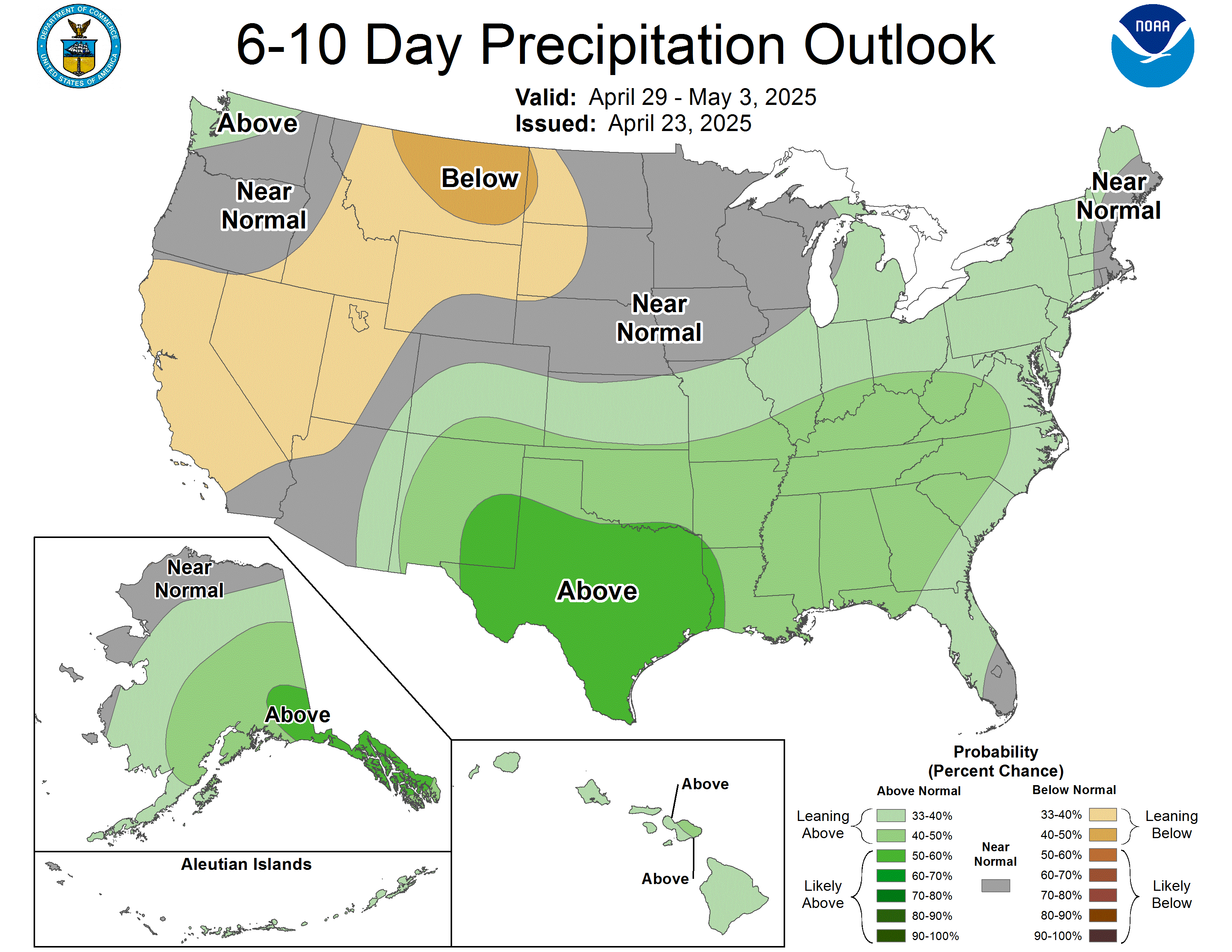
6–10 Day Precipitation Outlook
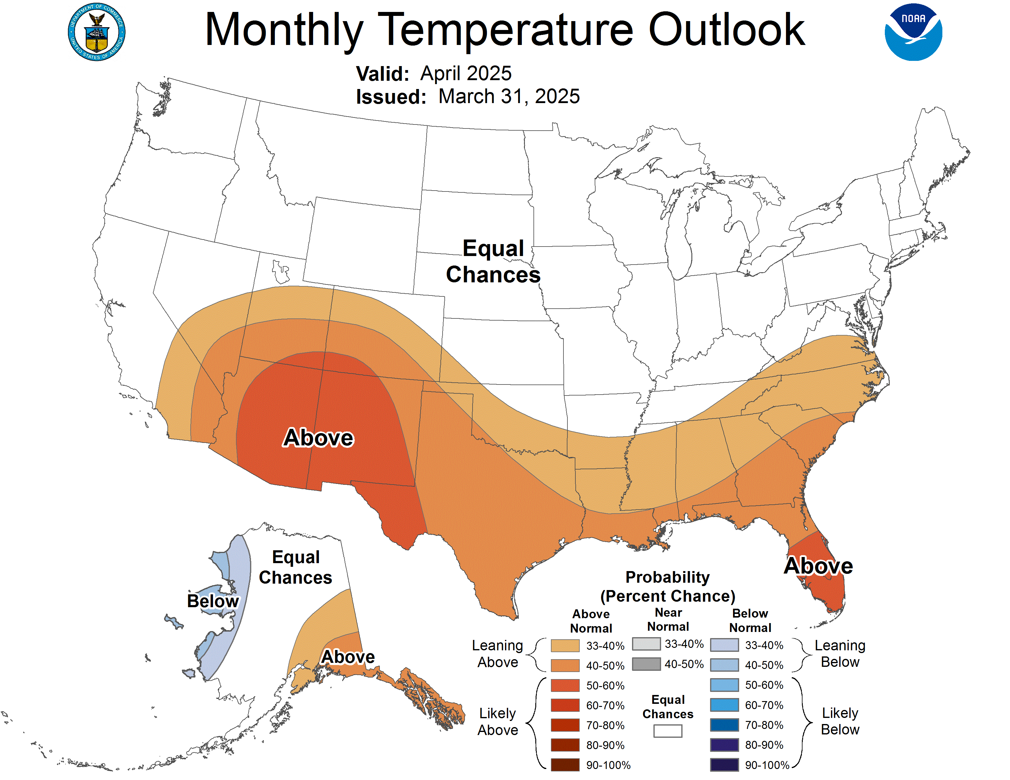
30-Day Temperature Outlook
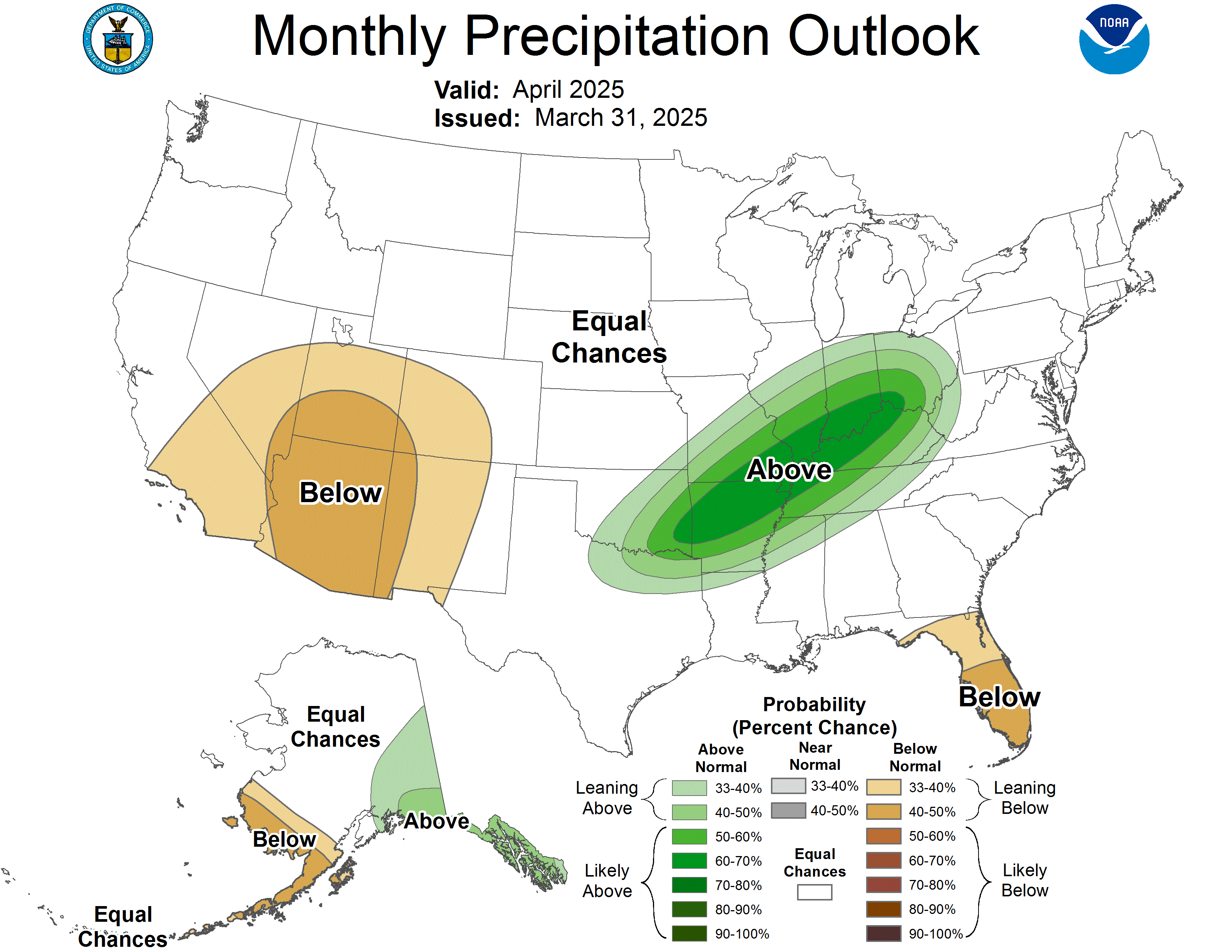
30-Day Precipitation
60-Day Temperature Outlook
60-Day Precipitation — Lead 2
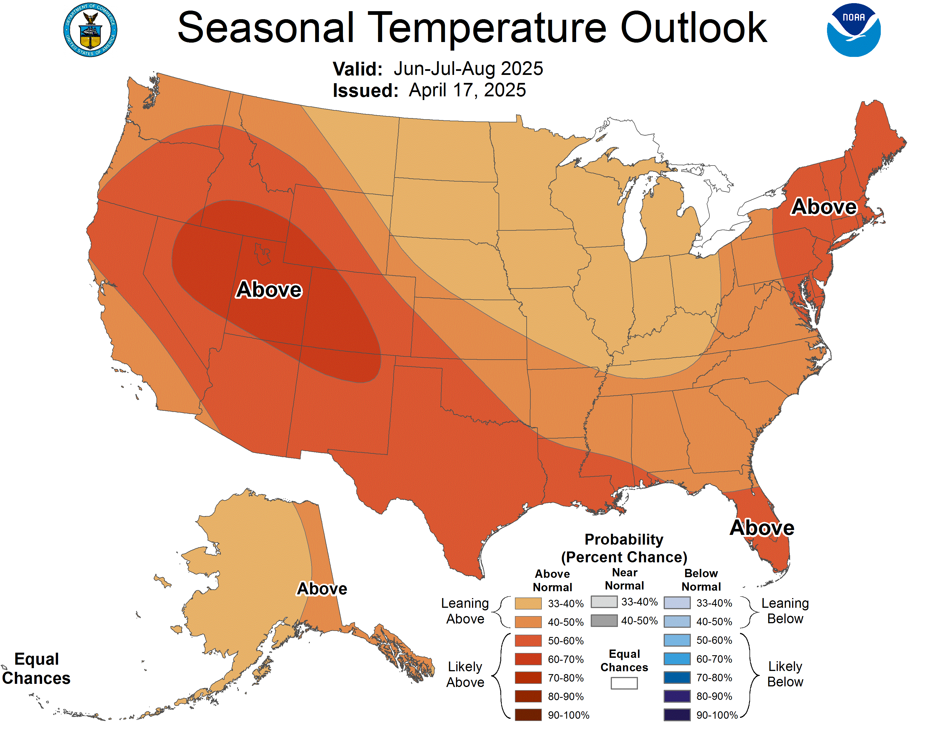
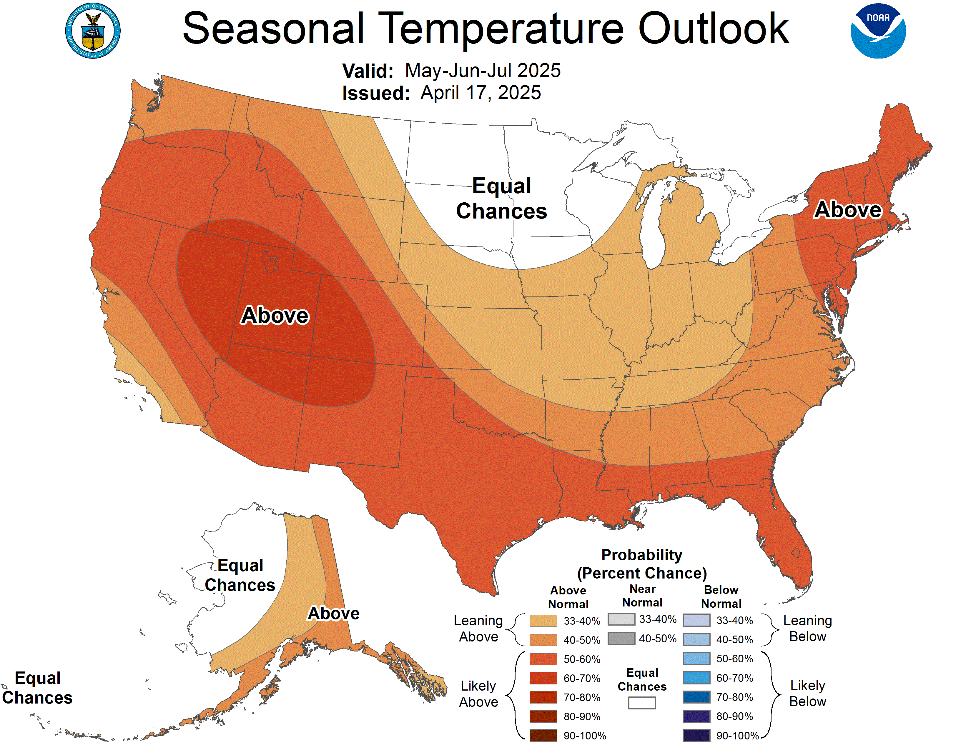
90-Day Temperature Outlook
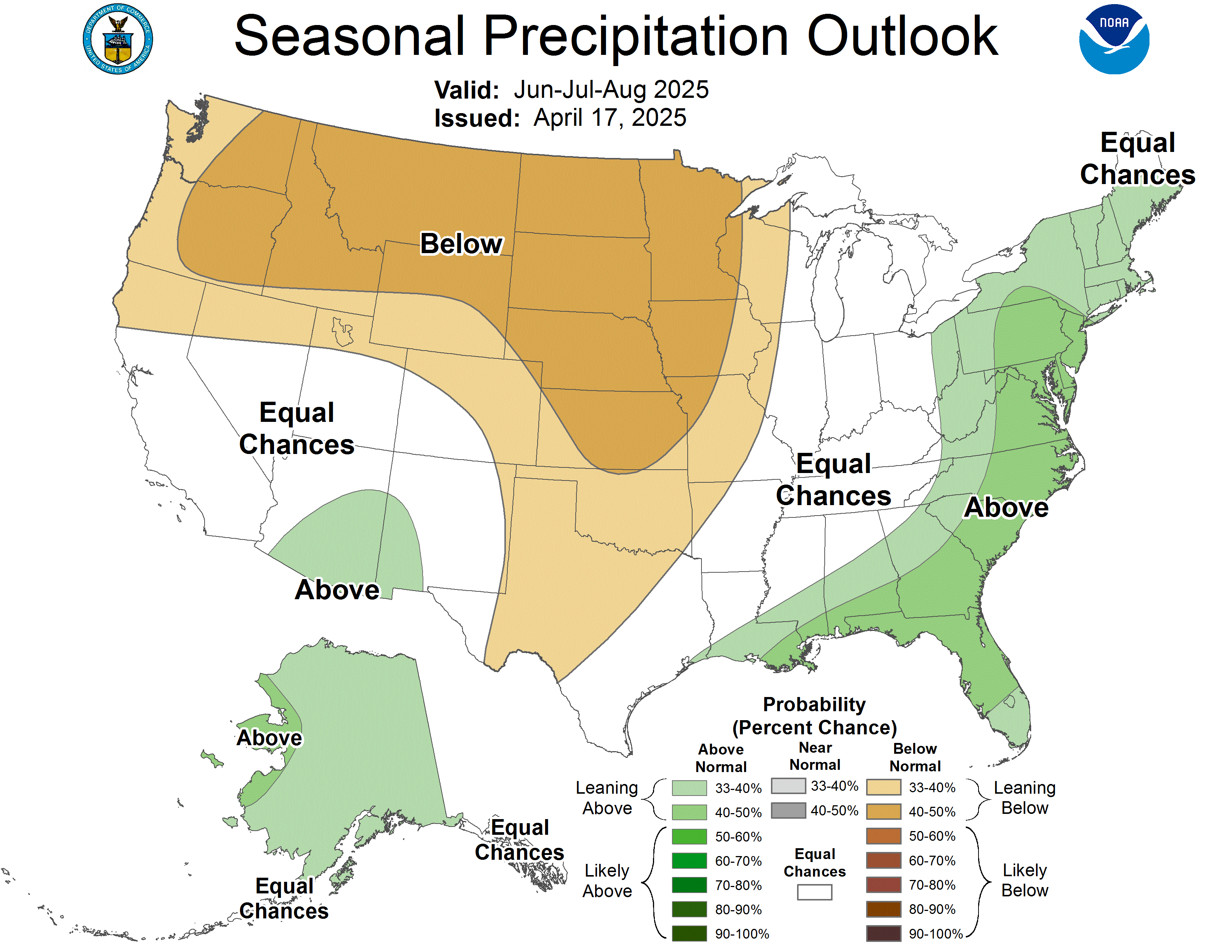
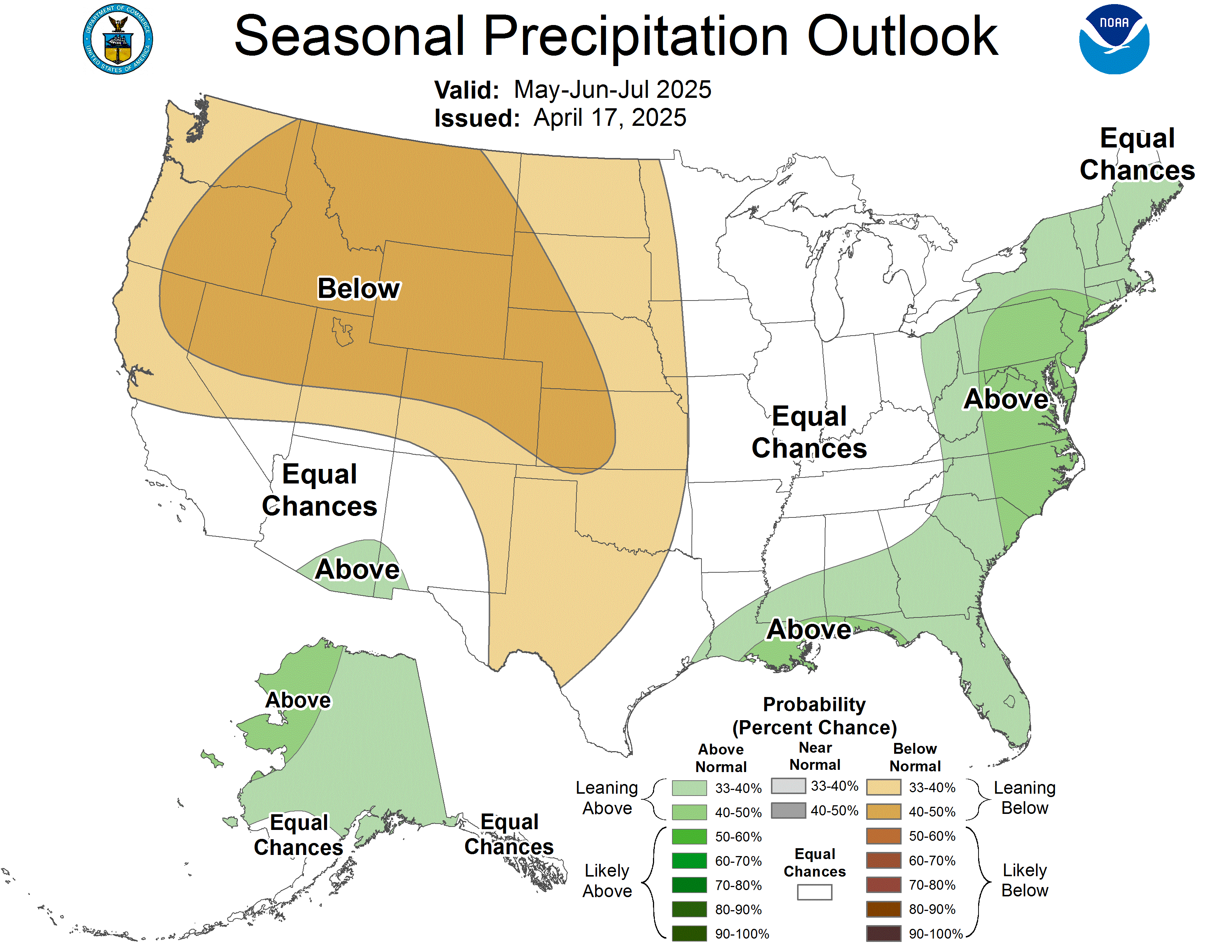
90-Day Precipitation — Lead 1

The Transactionalization of Awe

It has been a while since I published one of these. I would love to tell you the silence was due to a month-long spiritual retreat in a remote monastery, but the truth is far more mundane. Mostly, I have been trying to figure out exactly how many grams of coffee belong in a refillable pod without triggering a structural revolt from a Swiss espresso machine, and navigating the endless, self-replenishing conveyor belt of administrative logistics that makes up a modern Tuesday.

But I want to write more, because it feels like we are living through a bizarre, tectonic cultural shift, and if we don’t write it down, we might forget how strange it all was.

If you read the headlines, this transformation is entirely about AI, silicon chips, and large language models. But on the ground, in the actual physical territory of our lives, the shift is much weirder. Just look at us. We walk around in moisture-wicking, aerodynamic, thermal-regulated quarter-zips to sit in ergonomic chairs and send emails. We are a people dressed for a winter ascent of K2, currently attempting to conquer our inboxes. We have optimized our gear, our diets, and our sleep scores, but I am starting to wonder what it is we actually savor.

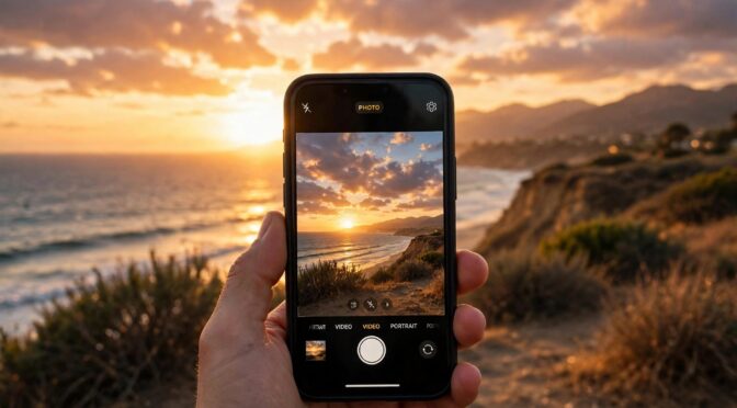
Take the sunset. The other evening, the sky over the Pacific did that specific thing where it turns the color of a bruised peach and seems to demand absolute, physical silence. But we don’t do silence anymore. Instead, if you look down the coast, you will see a dozen people holding up glowing glass rectangles, frantically swiping at exposure settings. We take the sheer, terrifying majesty of the cosmos and try to force it through a digital filter so we can harvest forty “likes” from people we haven’t spoken to since high school.

It is the transactionalization of awe. We are terrified of experiencing something beautiful and just keeping it to ourselves. If it isn’t documented, optimized, and leveraged for social capital, we worry it didn’t happen.

And I think this is exactly why we are currently starving for grace. Grace is the hardest concept for the modern mind to grasp because it is magnificently, stubbornly inefficient. It defies the logic of the world we have built. We live in a ledger-based society—everything is an exchange, a debt, a favor owed, a metric tracked.

But grace doesn’t scale. It is the guy on the 101 who lets you merge when he legally had the right of way. It is a thirty-minute conversation with a friend about a sprained wrist that produces absolutely zero economic value. It is the unearned, un-optimized space between two people. You cannot put it on a spreadsheet, which means the modern world doesn’t quite know what to do with it.

If you want to hear this tension out loud, listen to the Moonshots podcast. The hosts are the titans of Silicon Valley, guys like Peter Diamandis and Salim Ismail, and they speak about the future with the terrifying, unblinking cheerfulness of men who have just solved the math of the universe. They talk about infinite abundance, automated robot workforces, and curing aging as if these are just software patches downloading in the background.

And let me be clear: if you don’t think this technology is arriving, and arriving fast, you are driving looking in the rearview mirror. They are right about the raw capability of what is coming.

But as I listen to them, I get this sinking feeling that they are entirely willing to leap right over the actual human experience. In their worldview, everything is a certainty, a solvable equation. They want to colonize Mars and merge with the cloud, but I get the distinct sense they would be completely lost trying to figure out what to do on a rainy Tuesday afternoon in San Luis Obispo if their Wi-Fi went down.

The ultimate technologists look at the friction of human life—the miscommunications, the physical fatigue, the standing in line at the grocery store, the ambiguity of a new relationship—and see a latency issue to be engineered away.

But you cannot optimize the experience of watching your kid hit a golf ball. You cannot A/B test a moment of quiet gratitude. The friction isn’t a bug in the system. The friction is the system. It is the only place the sublime actually lives. I am trying to remind myself to look up from the dashboard, put the phone in my pocket, and just let the un-optimized present be enough.